Deadliest Volcanoes In The World
Tambora,
Indonesia

Mount Tambora is an active stratovolcano, also known as a
composite volcano, on the island of Sumbawa, Indonesia. Sumbawa is flanked both
to the north and south by oceanic crust, and Tambora was formed by the active
subduction zone beneath it. This raised Mount Tambora as high as 4,300 m
(14,100 ft), making it formerly one of the tallest peaks in the Indonesian
archipelago. After a large magma chamber inside the mountain filled over the
course of several decades, volcanic activity reached an historic climax in the
super-colossal eruption of April 10, 1815. The 1815 eruption was approximately
VEI 7, the only eruption of that size since the Lake Taupo eruption in about
180 CE.
With an estimated ejecta volume of 160 km3 (38 cu mi), Tambora's
1815 outburst was the largest volcanic eruption in recorded history. The
explosion was heard on Sumatra island more than 2,000 km (1,200 mi) away. Heavy
volcanic ash falls were observed as far away as Borneo, Sulawesi, Java and
Maluku islands. Most deaths from the eruption were from starvation and disease,
as the eruptive fallout ruined agricultural productivity in the local region.
The death toll was at least 71,000 people , of whom 11,000–12,000 were killed
directly by the eruption the often-cited figure of 92,000 people killed is
believed to be overestimated.
Ruiz, Colombia

The Nevado del Ruiz, also known as La Mesa de Herveo is a volcano located on the border of the departments of Caldas and Tolima in Colombia, about 129 kilometers west of the capital city Bogotá. It is a stratovolcano, composed of many layers of lava alternating with hardened volcanic ash and other pyroclastic rocks. Nevado del Ruiz has been active for about two million years, since the early Pleistocene or late Pliocene epoch, with three major eruptive periods. The current volcanic cone formed during the "present" eruptive period, which began 150 thousand years ago.
The volcano usually generates Plinian eruptions, which produce swift-moving currents of hot gas and rock called pyroclastic flows. These eruptions often cause massive lahars which pose a threat to human life and the environment. On November 13, 1985, a small eruption produced an enormous lahar that buried and destroyed the town of Armero in Tolima, causing an estimated 25,000 deaths. This event later became known as the Armero tragedy,the deadliest lahar in recorded history. Similar but less deadly incidents occurred in 1595 and 1845, consisting of a small explosive eruption followed by a large lahar.The volcano is part of Los Nevados National Natural Park, which also contains several other volcanoes. The summit of Nevado del Ruiz is covered by large glaciers, although these have retreated significantly since 1985 because of atmospheric warming. The volcano continues to pose a threat to the nearby towns and villages, and it is estimated that up to 500,000 people could be at risk from lahars from future eruptions.
Unzen, Japan
 Mount Unzen is an active volcanic group of several overlapping stratovolcanoes, near the city of Shimabara, Nagasaki Prefecture, on the island of Kyūshū, Japan’s southernmost main island.
In 1792, the collapse of one of its several lava domes triggered a megatsunami that killed about 15,000 people in Japan’s worst-ever volcanic-related disaster. The volcano was most recently active from 1990 to 1995, and a large eruption in 1991 generated a pyroclastic flow that killed 43 people, including three volcanologists..
Krakatau,
Indonesia

Krakatoa was a volcanic island in the Sunda Strait between the
islands of Java and Sumatra in Indonesia. The name is used for the island
group, the main island and the volcano as a whole. The volcano exploded
in 1883, killing 36,417 people. The explosion is considered to be the loudest
sound ever heard in modern history, with reports of it being heard nearly 3,000
miles (4,800 km) from its point of origin.
Mount Pelee,
Martinique

Mount Pelée is an active
volcano at the northern end of the island and French overseas department of
Martinique in the Lesser Antilles island arc of the Caribbean. Its volcanic
cone is composed of layers of volcanic ash and hardened lava.The stratovolcano
is famous for its eruption in 1902 and the destruction that resulted, dubbed
the worst volcanic disaster of the 20th century. The eruption killed about
30,000 people. Most deaths were caused by pyroclastic flows and occurred in the
city of Saint-Pierre, which was, at that time, the largest city on the
island.Pyroclastic flows completely destroyed St. Pierre, a town of 30,000
people, within minutes of the eruption.The eruption left only two survivors in
the direct path of the volcano.The event marked the only major volcanic
disaster in the history of France and its overseas territories.
Laki,
Iceland

Laki is a volcanic fissure in
the south of Iceland. Lakagígar is the correct name, as Laki mountain itself
did not erupt, but fissures opened up on each side of it. Lakagígar is part of
a volcanic system centered on the Grímsvötn volcano and including the
Þórðarhyrna volcano.It lies between the glaciers of Mýrdalsjökull and
Vatnajökull, in an area of fissures that run in a south-west to north-east
direction.The system erupted over an eight-month period between 1783 and 1784
from the Laki fissure and the adjoining Grímsvötn volcano, pouring out an estimated
14 km3 (3.4 cu mi) of basalt lava and clouds of poisonous hydrofluoric acid and
sulfur dioxide compounds that killed over 50% of Iceland's livestock
population, leading to a famine that killed approximately 25% of the island's
human population.The Laki eruption and its aftermath caused a drop in global
temperatures, as sulfur dioxide was spewed into the Northern Hemisphere. This
caused crop failures in Europe and may have caused droughts in India. The
eruption has been estimated to have killed over six million people
globally,making the eruption the deadliest in historical times.
Kelut,
Indonesia

Kelud is a volcano located in
East Java on Java in Indonesia. Like many Indonesian volcanoes and others on
the Pacific Ring of Fire, Kelud is known for large explosive eruptions
throughout its history. More than 30 eruptions have occurred since 1000 AD.
Galunggung,
Indonesia

Mount Galunggung is an active
stratovolcano in West Java, Indonesia, around 80 km southeast of the West Java
provincial capital, Bandung . Mount Galunggung is part of the Sunda Arc
extending through Sumatra, Java and Bali, which has resulted from the
subduction of the Australian plate beneath the Eurasian plate.For the first
time since 1982 after eruptions finished and conditions seemed normal, on
February 12, 2012 the status was upgraded to Alert based on changes in
conditions.
Vesuvius,
Italy

Mount Vesuvius is a
stratovolcano in the Gulf of Naples, Italy, about 9 kilometres (5.6 mi) east of
Naples and a short distance from the shore. It is the only volcano on the
European mainland to have erupted within the last hundred years, although it is
not currently erupting. The two other major active volcanoes in Italy, Etna and
Stromboli, are located on the islands of Sicily and Stromboli
respectively.Mount Vesuvius is best known for its eruption in AD 79 that led to
the burying and destruction of the Roman cities of Pompeii and Herculaneum.
They were never rebuilt, although surviving townspeople and probably looters
did undertake extensive salvage work after the destructions. The towns'
locations were eventually forgotten until their accidental rediscovery in the
18th century.The eruption also changed the course of the Sarno River and raised
the sea beach, so that Pompeii was now neither on the river nor adjacent to the
coast. Vesuvius itself underwent major changes , its slopes were denuded of
vegetation and its summit changed considerably due to the force of the
eruption. Vesuvius has erupted many times since and is today regarded as one of
the most dangerous volcanoes in the world because of the population of
3,000,000 people living nearby and its tendency towards explosive
eruptions. It is the most densely populated volcanic region in the world.
Papandayan,
Indonesia

Mount Papandayan is a complex
stratovolcano, located in Garut Regency, to the southeast of the city of
Bandung in West Java, Indonesia. It is about 15 km to the southwest of the town
of Garut. At the summit, there are four large craters which contain active
fumarole fields. An eruption in 1772 caused the northeast flank to collapse
producing a catastrophic debris avalanche that destroyed 40 villages and killed
nearly 3,000 people. The eruption truncated the volcano into a broad shape with
two peaks and a flat area 1.1 km wide with Alun-Alun crater in the middle,
making the mountain look like a twin volcano. One of the peaks is called Papandayan
and the other Mount Puntang.Since 1772, only small phreatic eruptions were
recorded before an explosive eruption that began in November 2002. People,
including tourists, were urged to remain at least 2 kilometers (1.2 mi) from
the yellow craters on the 2,665-meter (8,743-foot) Mount Papandayan. On Friday
September 2, 2011, the Indonesian Volcanology and Geophysical Disaster
Mitigation Center reported that numerous shallow volcanic earthquakes had been
recorded along with other indications of volcanic activity. A spokesperson for
the Indonesian National Disaster Management Agency noted that if Mt Papandayan
erupted, over 170,000 people living in five nearby subdistricts (kecamatan) and
in 20 villages could be affected.Of the people likely to be affected, it was
expected that perhaps as many as 11,500 people might need to be evacuated.
Agung, Indonesia

Mount Agung or Gunung Agung is a mountain in Bali, Indonesia. This stratovolcano is the highest point on the island. It dominates the surrounding area and influencing the climate. The clouds come from the west and Agung takes their water so that the west is lush and green and the east dry and barren.The Balinese believe that Mount Agung is a replica of Mount Meru, the central axis of the universe. One legend holds that the mountain is a fragment of Meru brought to Bali by the first Hindus. The most important temple on Bali, Pura Besakih, is located high on the slopes of Gunung Agung.Gunung Agung last erupted in 1963-1964 and is still active, with a large and very deep crater which occasionally belches smoke and ash. From a distance, the mountain appears to be perfectly conical, despite the existence of the large crater.From the peak of the mountain, it is possible to see the peak of Mount Rinjani on the island of Lombok, although both mountains are frequently covered in cloud.
Cotopaxi, Ecuador

Cotopaxi is a stratovolcano in the Andes Mountains, located about 28 km (17 mi) south of Quito, Ecuador, South America. It is the second highest summit in the country, reaching a height of 5,897 m (19,347 ft)Cotopaxi has an almost symmetrical cone that rises from a highland plain of about 3,800 metres (12,500 ft), with a width at its base of about 23 kilometres (14 mi). It has one of the few equatorial glaciers in the world, which starts at the height of 5,000 metres (16,400 ft). The mountain is clearly visible on the skyline from Quito. It is part of the chain of volcanoes around the Pacific plate known as the Pacific Ring of Fire.
Pinatubo, Philippines
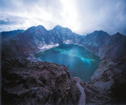
Mount Pinatubo is an active stratovolcano located on the island of Luzon, near the tripoint of the Philippine provinces of Zambales, Tarlac, and Pampanga. It is located in the Cabusilan Mountains separating the west coast of Luzon from the central plains. Before the volcanic activities of 1991, its eruptive history was unknown to most people. It was heavily eroded, inconspicuous and obscured from view. It was covered with dense forest which supported a population of several thousand indigenous people, the Aetas, who fled to the mountains during the Spanish conquest of the Philippines.The volcano's Plinian eruption on June 15, 1991 produced the second largest terrestrial eruption of the 20th century after the 1912 eruption of Novarupta in the Alaska Peninsula. Complicating the eruption was the arrival of Typhoon Yunya bringing a lethal mix of ash and rain. Successful predictions at the onset of the climactic eruption led to the evacuation of tens of thousands of people from the surrounding areas, saving many lives, but the surrounding areas were severely damaged by pyroclastic flows, ash deposits, and subsequently, by the lahars caused by rainwaters re-mobilizing earlier volcanic deposits destroying thousands of infrastructures and altering the river systems months to years after the eruption.The effects of the eruption were felt worldwide. It ejected roughly 10,000,000,000 tonnes or 10 km3 (2.4 cu mi) of magma, and 20,000,000 t (22,000,000 short tons) SO2, bringing vast quantities of minerals and metals to the surface environment. It injected large amounts of aerosol into the stratosphere – more than any eruption since that of Krakatoa in 1883. Over the following months, the aerosols formed a global layer of sulfuric acid haze. Global temperatures dropped by about 0.5 °C (0.900 °F), and ozone depletion temporarily increased substantiall.
Hibok-Hibok, Philippines

Mount Hibok-Hibok is a stratovolcano on Camiguin Island in the Philippines.It is one of the active volcanoes in the country and part of the Pacific ring of fire.
Lamington,
Papua New Guinea

Mount Lamington is an andesitic
stratovolcano in the Oro Province of Papua New Guinea. The forested peak of the
volcano had not been recognised as such until its devastating eruption in 1951
that caused about 3,000 deaths.The volcano rises to 1680 m above the coastal
plain north of the Owen Stanley Range. A summit complex of lava domes and
crater remnants rises above a low-angle base of volcaniclastic deposits that
are dissected by radial valleys. A prominent broad "avalanche valley"
extends northward from the breached crater.
El
Chichon, Mexico

El Chichón, also known as Chichonal is
an active volcano in Francisco León Municipality in northwestern Chiapas,
Mexico. Its only recorded eruptive activity was on March 29, April 3 and April
4, 1982,when it produced a one km-wide caldera that then filled with an acidic
crater lake. The eruption killed around 2,000 people who lived near the
volcano. It had high-sulfur anhydrite-bearing magma, explosive eruptions,
pyroclastic flows, and surges that were devastating to the area surrounding the
volcano.In 2000, the lake's water temperature increased. Also, the lake
acquired a blue-green color, due to massive amounts of dissolved minerals in
the acidic water, and fine, light-colored ashy sediment continually stirred up
by boiling areas.El Chichon is part of a geologic zone known as the Chiapanecan
Volcanic Arc. This volcanic region is thought to be the result of the
subduction of the Tehuantepec Ridge, an undersea ridge which lies on the Cocos
Plate off the Pacific coast of Mexico.
Soufriere,
St. Vincent

Soufrière Saint Vincent is an active
volcano on the island of Saint Vincent in the Windward Islands of the
Caribbean.At 1,234 m (4,049 ft), La Soufrière is the highest peak on Saint
Vincent as well as the highest point in the island country of Saint Vincent and
the Grenadines. Soufrière is a stratovolcano with a crater lake and is the
island's youngest and northernmost volcano.
Asama,
Japan

Mount Asama is an active complex
volcano in central Honshū, the main
island of Japan. The volcano is the most active on Honshū. The Japan Meteorological Agency
classifies Mount Asama as rank A. It stands 2,568 metres (8,425 ft) above sea
level on the border of Gunma and Nagano prefectures.
Taal,
Philippines

Taal Volcano is a complex volcano
located on the island of Luzon in the Philippines. Historical eruptions are
concentrated on Volcano Island, an island near the middle of Lake Taal. The
lake partially fills Taal Caldera, which was formed by powerful prehistoric
eruptions between 140,000 to 5,380 BP. Viewed from Tagaytay Ridge, Taal Volcano
and Lake presents one of the most picturesque and attractive views in the Philippines.
It is located about 50 km (31 mi) south of the capital of the country, the city
of Manila.The volcano had several violent eruptions in the past causing loss of
life in the island and the populated areas surrounding the lake, with the death
toll estimated at around 5,000 to 6,000. Because of its proximity to populated
areas and its eruptive history, the volcano was designated a Decade Volcano,
worthy of close study to prevent future natural disasters. It is one of the
active volcanoes in the Philippines and part of the Pacific ring of fire.
Mayon, Philippines

Mayon Volcano, also known as Mount
Mayon, is an active volcano in the province of Albay, on the island of Luzon in
the Philippines. Renowned as the "perfect cone" because of its almost
symmetric conical shape, Mayon forms the northern boundary of Legazpi City, the
largest city in terms of population in the Bicol Region. The mountain is a
national park and a protected landscape in the country proclaimed as Mayon
Volcano Natural Park in the year 2000.


No comments:
Post a Comment